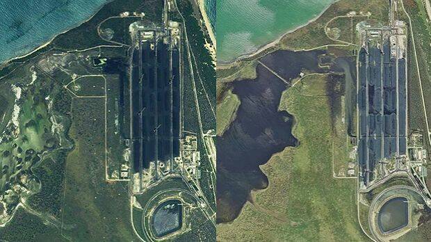
The Queensland government is investigating water spills from the Abbot Point coal terminal into neighbouring wetlands as an expert predicts long-term environmental damage.
The Department of Environment and Heritage Protection was assessing whether there were any unauthorised water releases from the Adani-operated coal terminal into the wetland after Cyclone Debbie tore through north Queensland late last month.
The EHP and Adani said early indications showed all spills were within guidelines.
But James Cook University professorial research fellow in water quality studies Professor Jon Brodie said coal had clearly spilled into the wetlands and environmental harm was "highly likely".
His comments came in the wake of the release of striking satellite imagery from before and after the storm, appearing to show coal-laden water spilling throughout the sensitive Caley Valley wetlands.
The Mackay Conservation Group said the 5000-hectare wetlands were home to 40,000 shorebirds in the wet season and more than 200 individual species.
The department allowed terminal operator Abbot Point Bulk Coal, owned by Adani, to more than triple its "suspended solids" release limits in the wake of Cyclone Debbie, under what's called a Temporary Emissions Licence.
A department spokeswoman said that licence did not authorise environmental harm but Professor Brodie said it was hard to see how the wetlands could emerge unscathed.
"Obviously wetlands depend on light," he said, calling for a full examination.
"Those plants at the bottom, there won't be too much light there for a while.
"That will settle out of course and it will settle out to the bottom onto the plants that are on the bottom.
"There'll be significant damage from this but that should be quantified."
The EHP spokeswoman said investigations were continuing but initial monitoring showed the terminal operator's releases into the wetlands were in line with its conditions.
"The TEL permitted a temporary increase in the release limits for total suspended solids from 30 mg/L to 100 mg/L," she said, in a statement.
"By comparison, the total suspended solids in central Queensland waterways following rainfall events typically exceed 1000 mg/L."
Mackay Conservation Group co-ordinator Peter McCallum, whose organisation released the images, said they showed the wetlands had been "turned black by coal escaping from the port".
"Adani is putting itself forward as this responsible environmental payer but its behaviour is completely the opposite," he said.
"It's doing what it says is within the rules but anyone within two eyes can see that what they've done at the Caley Valley wetlands is horrendous and it's really going to have a severe impact on those wetlands and the wildlife that depends upon them.
The group successfully fought an early approval for the Indian giant's Carmichael mine in the Federal Court in 2015 and professor Brodie had previously agreed to be an expert witness for the group.
An Adani spokesman said the company had complied with the conditions and no spill had made its way to the adjacent sea.
"In the wake of the category 4 Tropical Cyclone Debbie, the company has been working closely with the Department of Environment and Heritage Protection to ensure that we comply with the special and rigorous conditions of the special licence," the spokesman said.
An EHP spokesman said it was not yet safe to access equipment at the site, meaning the amount of water released could not be measured.
"Water sampling has been undertaken by the company and EHP will conduct further sampling to check water quality and any detrimental impacts to the wetlands once access to the site is obtained," he said, in a statement.
- This article was first published on the Brisbane Times website.

